Multi-Sensor Perception
Each sensor has its strengths. By fusing multiple modalities, we achieve perception beyond any single technology.
mmWave Radar
Millimeter Wave Radar
High-resolution imaging through fog, dust, and darkness. Ideal for industrial monitoring and autonomous navigation.
- +All-weather operation
- +Velocity measurement
- +Non-contact detection
LiDAR Systems
Laser Detection System
Precise 3D point cloud generation for surveying, mapping, and object detection with centimeter-level accuracy.
- +High precision 3D
- +Long range detection
- +Point cloud mapping
Computer Vision
AI Vision System
AI-powered image analysis for object recognition, defect detection, and scene understanding in real-time.
- +Rich visual context
- +AI object detection
- +Pattern recognition
Ground Penetrating Radar
Subsurface Imaging
See beneath the surface. Detect underground utilities, voids, and anomalies non-destructively.
- +Subsurface imaging
- +Non-destructive
- +Utility detection
The Whole is Greater
Than the Sum of Parts
Our AI-powered fusion algorithms combine data from multiple sensors to create a unified perception that exceeds the capability of any individual sensor. This enables robust detection in complex and challenging environments.
Multi-Modal Fusion
Combine radar, LiDAR, and vision for comprehensive scene understanding
AI-Powered Analysis
Deep learning algorithms for intelligent decision making
Real-Time Processing
Edge computing for immediate insights and responses
Fusion Architecture
Multiple sensors → Unified perception
Applications
Enabling intelligent perception across industries
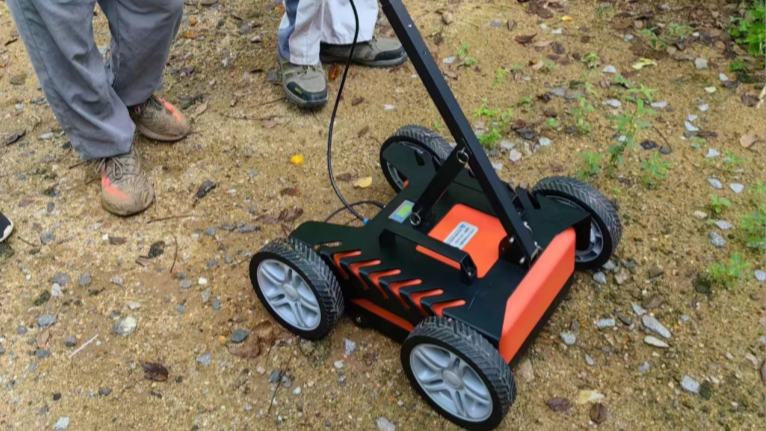
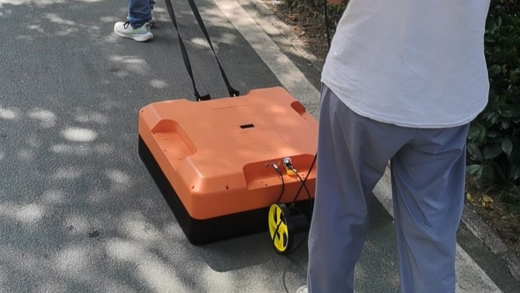
Ground Penetrating Radar Systems
Professional GPR systems for underground detection, utility mapping, and structural inspection. Multiple antenna frequencies for different depth and resolution requirements.
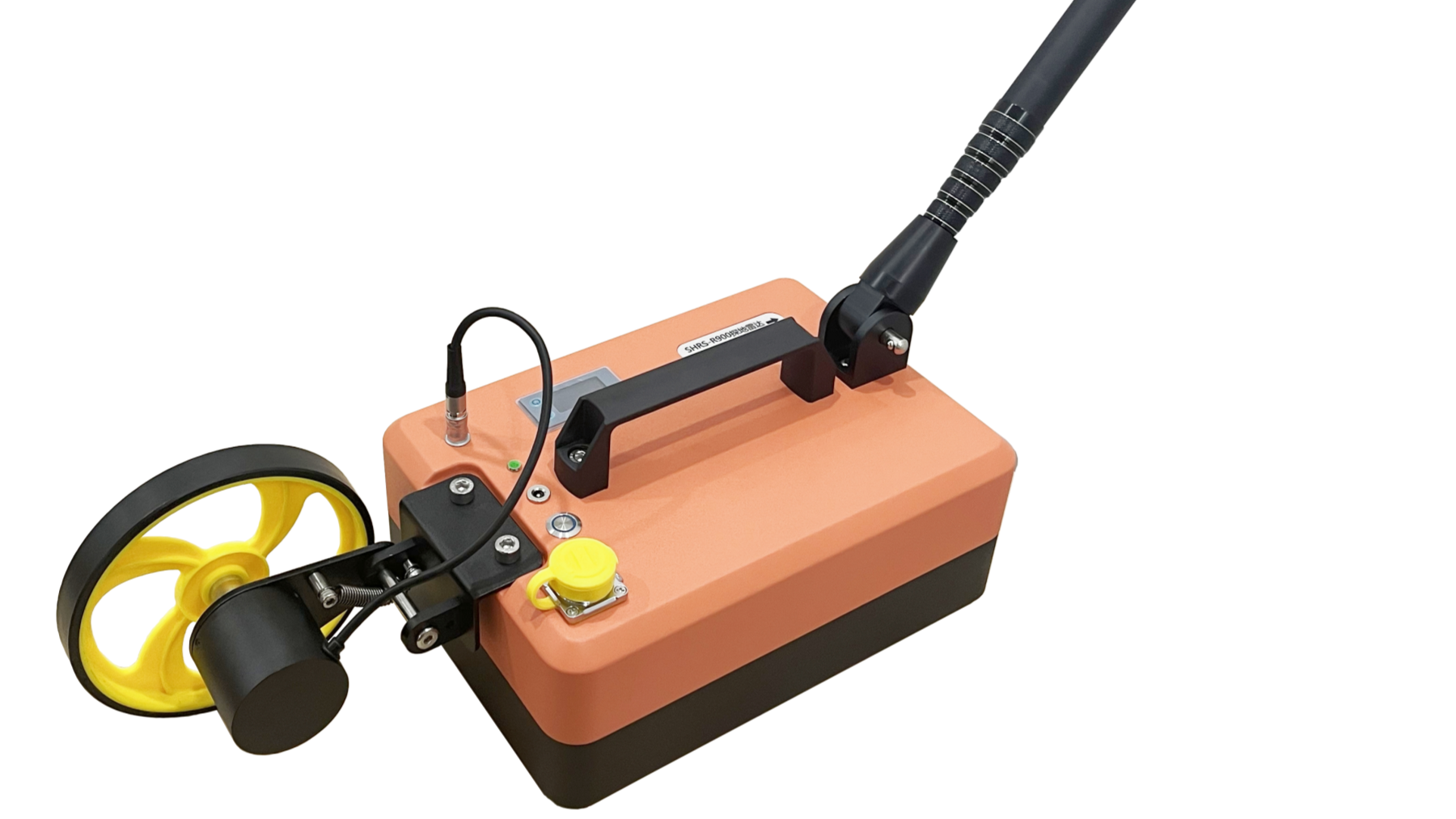

Common Technical Specifications
Built-in Li-ion Battery
Easy replacement, long field operation
Real-time Display
Laptop/Tablet with live A-Scan & B-Scan
RJ45 Interface
Standard network data transfer
Post Processing
Data display, target marking, reports
Frequently Asked Questions
Common questions about our sensing solutions
What is the difference between mmWave radar and LiDAR? +
mmWave radar uses radio waves and works in all weather conditions (fog, dust, rain), while LiDAR uses laser light for higher precision 3D mapping. We often combine both for robust perception in challenging environments.
What depth can GPR detect underground? +
Our GPR systems range from 0.8m (900 MHz for high resolution) to 15m+ (100 MHz for deep penetration). The choice depends on your application — shallow concrete inspection vs. deep geological surveys.
Can you provide custom sensor fusion solutions? +
Yes, we specialize in multi-sensor fusion. We can combine radar, LiDAR, camera, and other sensors with AI algorithms tailored to your specific detection requirements.
Do you provide training and support? +
Absolutely. All our systems come with comprehensive training, documentation, and ongoing technical support. We also offer on-site installation and calibration services.
Interactive Demonstrations
Explore our sensing technologies through interactive demos
Ready to See the Invisible?
Let's discuss how our sensing solutions can solve your perception challenges.
How Ground Penetrating Radar Works
A comprehensive guide to GPR technology, its principles, and how we apply it for underground utility detection in Belgium and across Europe.
The Science Behind GPR
Ground penetrating radar (GPR) works by emitting short pulses of electromagnetic energy into the ground through a transmitting antenna. When these radio waves encounter a boundary between materials with different electrical properties — such as the interface between soil and a buried pipe, or between concrete and an air void — part of the energy is reflected back to a receiving antenna on the surface. By measuring the time delay and amplitude of these reflections, GPR creates a cross-sectional image (called a radargram or B-scan) of the subsurface.
The key to effective GPR surveying lies in understanding the relationship between antenna frequency, penetration depth, and resolution. Higher frequency antennas (such as our 900 MHz SHRS-R900) provide excellent resolution — capable of detecting individual rebar in concrete at centimeter-level precision — but have limited depth penetration of approximately 0.8 to 1.5 meters. Conversely, lower frequency antennas (such as the 100 MHz SHRS-R100) can penetrate up to 15 meters in favorable soil conditions but with reduced resolution, making them ideal for deep geological surveys and tunnel advance prediction.
The propagation of GPR signals is governed by the dielectric permittivity and electrical conductivity of the subsurface materials. Dry sandy soils provide excellent penetration due to their low conductivity, while clay-rich soils and saline environments significantly attenuate the signal. In Belgium, where soil conditions vary from the sandy Flanders region to the clay-heavy Wallonian plateau, selecting the appropriate antenna frequency and survey parameters is critical for successful subsurface investigations. Our team has extensive experience with Belgian soil types and adjusts survey methodology accordingly.
Frequency Selection Guide
| Model | Frequency | Depth | Best For |
|---|---|---|---|
| SHRS-R900 | 900 MHz | 0.8–1.5 m | Concrete rebar, tunnel lining, pavement layers |
| SHRS-R400 | 400 MHz | 2–4 m | Structural defects, shallow utilities, retaining walls |
| SHRS-R200 | 200 MHz | 5–8 m | Road/bridge inspection, municipal pipelines, tunnels |
| SHRS-R100 | 100 MHz | 10–15 m | Geological hazards, deep exploration, landslides |
Technical Specifications (All Models)
- A/D Resolution: 16-bit high-precision sampling
- Sampling Rate: Up to 512 traces per second
- Scan Rate: 5–20 GHz equivalent bandwidth
- Interface: RJ45 Ethernet for data transfer
- Power: Built-in rechargeable Li-ion battery
- Display: Real-time A-Scan and B-Scan on laptop/tablet
- Data Format: Compatible with major GPR processing software
- Operating Temperature: -20°C to +50°C
GPR Data Processing & Analysis
Raw GPR data requires sophisticated post-processing to extract meaningful subsurface information. At Rays Technology, we use advanced processing workflows — including our RGPR analysis capabilities — to transform raw radargrams into clear, interpretable subsurface maps that engineers and project managers can act upon.
Our processing pipeline includes time-zero correction, dewow filtering to remove low-frequency DC bias, background removal to suppress horizontal ringing, bandpass filtering to isolate target reflections, gain application (SEC and AGC) to compensate for signal attenuation with depth, and migration to correct for geometric distortions. For 3D surveys, we generate volumetric datasets with depth slices that reveal the spatial extent of buried objects and anomalies at specific depths.
Every GPR survey we conduct includes comprehensive reporting: processed radargram profiles, annotated target locations with depth estimates, 3D visualization where applicable, and actionable recommendations. Our reports are formatted to meet the requirements of Belgian construction standards and can be directly used for KLIM/KLIP utility mapping submissions in Flanders.
Processing Workflow
Field survey with calibrated GPR equipment
Time-zero correction, dewow, background removal
Bandpass filtering, gain correction, migration
Target identification, depth calculation, mapping
Annotated profiles, 3D maps, KLIM/KLIP submission
LiDAR Technology for Precision 3D Mapping
Light Detection and Ranging (LiDAR) technology uses pulsed laser light to measure distances with extraordinary precision. By scanning thousands of laser pulses per second and recording the time-of-flight for each return, LiDAR systems generate dense 3D point clouds that represent the physical environment with centimeter-level accuracy. At Rays Technology, we integrate LiDAR into multi-sensor perception systems for surveying, infrastructure monitoring, and autonomous navigation.
Our LiDAR solutions cover both terrestrial and mobile scanning applications. Terrestrial LiDAR is used for detailed structural surveys of bridges, tunnels, and buildings — creating precise digital twins that engineers can analyze for deformation, settlement, and structural integrity. Mobile LiDAR, mounted on vehicles or drones, enables rapid corridor surveys for road networks, railway lines, and utility corridors. In Belgium, where infrastructure density is among the highest in Europe, LiDAR-based asset management is becoming an essential tool for municipalities and infrastructure operators.
When combined with our radar and computer vision systems, LiDAR data serves as a critical input to our sensor fusion engine. Radar provides robustness in adverse weather while LiDAR delivers geometric precision. Together with camera-based semantic understanding, the fused output provides a comprehensive, reliable perception of the environment that exceeds the capability of any individual sensor modality.
Millimeter-Wave Radar for All-Weather Sensing
Millimeter-wave (mmWave) radar operates at frequencies between 30 GHz and 300 GHz, enabling high-resolution imaging and precise motion detection in conditions that defeat optical sensors. Unlike cameras and LiDAR, mmWave radar sees through fog, heavy rain, dust, and darkness — making it indispensable for safety-critical applications where continuous, reliable perception is non-negotiable.
Our mmWave radar solutions leverage the latest FMCW (Frequency Modulated Continuous Wave) technology for simultaneous range, velocity, and angle measurement. These systems can detect and track multiple objects simultaneously, measuring not just position but also radial velocity through the Doppler effect — a capability unique to radar that allows discrimination between stationary infrastructure and moving targets like vehicles, pedestrians, and equipment.
Applications include industrial monitoring (detecting equipment movement and personnel safety zones), autonomous vehicle perception (providing reliable ranging in all conditions), building security (perimeter surveillance that works day and night), and smart traffic management (vehicle counting, speed measurement, and classification). Our radar systems range from compact single-chip solutions for embedded applications to multi-channel phased array systems for advanced imaging and MIMO radar processing.
Underground Pipeline Detection in Brussels
How GPR surveying prevented utility strikes during a major road rehabilitation project
The Challenge
A construction contractor in Brussels was tasked with rehabilitating a 2.5 km section of road in a densely urbanized area near Evere. Historical utility records were incomplete and outdated — common in Belgian cities where infrastructure has been layered over decades. The contractor needed accurate mapping of all underground utilities (gas, water, electricity, telecom) before excavation could begin, as utility strikes would cause costly delays and safety hazards.
Our Solution
Rays Technology deployed a multi-frequency GPR survey using both 400 MHz and 200 MHz antennas. The 400 MHz antenna provided high-resolution imaging of shallow utilities in the top 3 meters, while the 200 MHz antenna detected deeper infrastructure down to 6 meters. We conducted parallel survey lines at 0.5-meter spacing across the full road width, generating a comprehensive 3D subsurface model. Post-processing with migration and depth correction produced georeferenced utility maps overlaid on site plans.
Results
GPR & Sensing FAQ
Detailed answers to the most common questions about our sensing technologies
What types of underground objects can GPR detect in Belgium? +
GPR can detect a wide variety of subsurface objects and features commonly found in Belgian urban and rural environments. These include metallic utilities (gas pipes, water mains, electrical cables), non-metallic utilities (PVC pipes, fiber optic conduits, concrete drainage), underground voids and cavities, buried foundations and archaeological features, reinforcing steel in concrete structures, road layer interfaces and delamination, and geological features such as bedrock depth, water table, and soil layer boundaries. The detection capability depends on the contrast in electrical properties between the target and surrounding soil, as well as the antenna frequency and soil conditions. In Belgium's clay-rich soils, penetration may be reduced compared to sandy areas in the Kempen or coastal regions.
How accurate is GPR for utility mapping compared to other methods? +
GPR typically achieves horizontal accuracy of ±5-10 cm and depth accuracy of ±10-15% of the target depth when properly calibrated. This compares favorably with electromagnetic locators (which only detect metallic utilities) and is significantly more informative than relying solely on as-built drawings, which are often outdated or incomplete in Belgium's older urban areas. For highest accuracy, we combine GPR with electromagnetic induction (EMI) methods and GNSS positioning. Our surveys typically achieve Quality Level B (QL-B) according to ASCE 38-02 standards, with verification excavations available for QL-A designation when required by the project. For KLIM/KLIP submissions in Flanders, our GPR survey data meets or exceeds the required accuracy standards.
Can GPR work on all soil types found in Belgium? +
GPR performance varies with soil type due to differences in electrical conductivity. In Belgium, sandy soils in the Kempen region and coastal areas provide excellent GPR penetration, often exceeding the nominal depth specifications of our antennas. Loamy soils in central Belgium (Brabant, Hainaut) offer moderate performance. Heavy clay soils, found in parts of Wallonia and some river valleys, present the greatest challenge due to high signal attenuation. However, even in clay-rich areas, GPR remains effective for shallow investigations (top 1-2 meters) using higher-frequency antennas. We always conduct a preliminary site assessment to evaluate soil conditions and recommend the most appropriate survey methodology. In challenging soil conditions, we may recommend complementary techniques such as electromagnetic induction or seismic methods.
How long does a typical GPR survey take? +
Survey duration depends on the area size, required resolution, and number of antenna frequencies. As a general guide: a small site survey (e.g., 500 m² construction plot) can be completed in half a day including setup and calibration. A medium road corridor survey (500-1000 linear meters) typically requires 1-2 days of field work. Large-scale infrastructure surveys (multiple kilometers) may take 1-2 weeks depending on complexity. After field work, data processing and report generation typically adds 3-5 working days for standard projects, or 1-2 weeks for complex 3D surveys. We provide detailed project timelines and cost estimates during the quotation phase, and our team is experienced in working alongside active construction schedules to minimize disruption.
Do you offer GPR equipment sales or only survey services? +
We offer both. Our SHRS series GPR systems (R100, R200, R400, R900) are available for purchase, ideal for engineering firms, geotechnical consultants, and inspection companies that conduct regular subsurface investigations. Each system comes with comprehensive training, calibration, and ongoing technical support. We also provide professional GPR survey services for clients who prefer to outsource the surveying work — particularly useful for one-time projects or organizations without in-house GPR expertise. Additionally, we offer GPR equipment rental for short-term projects, along with operator training programs for teams looking to build internal capability.
What is the difference between LiDAR and photogrammetry for 3D mapping? +
LiDAR and photogrammetry are both used for 3D mapping, but they have fundamentally different strengths. LiDAR actively emits laser pulses and measures returns, providing direct geometric measurements that are highly accurate regardless of lighting conditions. It excels in vegetated areas (laser pulses can penetrate canopy to measure ground elevation), low-light environments, and applications requiring centimeter-level accuracy. Photogrammetry derives 3D information from overlapping photographs using structure-from-motion algorithms — it's generally lower cost and provides photorealistic texture but requires good lighting and struggles with vegetation and featureless surfaces. For infrastructure inspection and precision surveying in Belgium, we typically recommend LiDAR for its superior accuracy and reliability. For visual documentation and texture mapping, photogrammetry can complement LiDAR data effectively.
Related Solutions
Explore how our sensing technologies integrate with other Rays Technology platforms
🤖 AI-Powered Analysis
Our AI solutions process sensor data in real-time for automated detection, classification, and anomaly identification. Ideal for combining with GPR and LiDAR data.
📡 RF & Wireless Connectivity
Reliable wireless communication for remote sensor deployments, real-time data streaming from field sensors, and IoT connectivity for monitoring systems.
⚡ Smart Energy Integration
Perception sensors detect vehicles and monitor parking areas for our PowerCourier mobile EV charging platform, enabling intelligent dispatch and demand prediction.